| Before GIS resources such as as Open Street Maps or Natural Earth gave mapmakers access to non-copyrighted databases, cartographic plagiarism was a major concern. To avoid seeing their efforts stolen by competitors, cartographers and map publishers would often resort to a ruse: the copyright trap. Copyright traps could take several forms. They could consist of purposefully misrepresenting the shape and curviness of a road, or inventing one altogether. Ideally, these "trap streets" would be small enough to not have an impact on those actually using the map. A copyright trap could also be a whole hamlet, like Agloe, in upstate New York. That fictional town first made its way to a General Drafting Company map of New York State in the 1930s, straight out of the imagination (and initials) of mapmakers Otto Lindberg and Ernest Alpens. Later, a convenience store bearing the name opened on the site, effectively putting Agloe on the map for real, briefly. (The store later closed.) 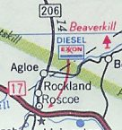 Town of Agloe, appearing on a 1998 Exxon map. Credit: Ian Byrne via Wikipedia Google Maps originally relied on data served by the Dutch mapping company Tele Atlas. Their database was peppered with copyright traps that made their way into the original maps of the search giant: Take Moat Lane, in London, or Oxygen Street, in Edinburgh. Google would erase them as soon as notified. In 2010, for example, the fake town of Argleton, England, disappeared from the system. The name was, according to some, an anagram of "Not real G[oogle]." 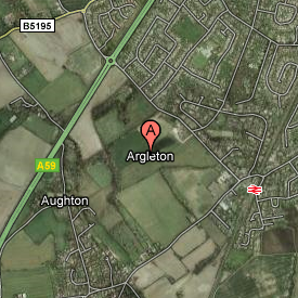 Argleton, appearing on Google Maps, circa 2009. Credit: Google Maps via Wikipedia Copyright traps aren't exclusive to maps. Encyclopedias and dictionaries would sometimes feature fake entries known as "mountweazels" — a reference to Lilian V. Mountweazel, a fictional photographer and fountain designer from Ohio who was inserted into the 1975 edition of The New Columbia Encyclopedia in order to trip up potential copyright violators. Some mountweazels, such as the word "esquivalience", were identified as recently as in the 2005 edition of the New Oxford American Dictionary. If you saw your fake road or town featured on another map, you could conclude that someone had violated your copyright. But not anymore. At least not in the US. In a 2001 article titled "Map Traps," geographer Mark Monmonier (author of the seminal 1991 book How To Lie With Maps) writes that "trap streets no longer have legal clout" since the 1991 lawsuit Feist v. Rural Telephone Company. Rural accused Feist Publications of copying its directories, after spotting four of its mountweazels in a Feist directory. The Supreme Court dismissed Feist, ruling that "American copyright law does not protect mere collections of facts." And in 1997, in Alexandria Drafting Co. v. Amsterdam, the district court for the eastern district of Pennsylvania ruled that "the existence, or non-existence, of a road is a non-copyrightable fact." While the legal usefulness of trap streets may be gone, a few of these phantom paths still linger on. Last week, the US Supreme Court overturned Roe v. Wade, putting an end to 50 years of a federal right to abortion. The decision stands to have enormous consequences in the lives of many millions of Americans. Those changes can already be seen on national maps. Following the decision, trigger bans in 13 states went into effect, making abortion forbidden in most or all cases within 30 days of the overturning of Roe. In Texas, abortions will be banned after six weeks, and the state will make no exception for rape or incest. 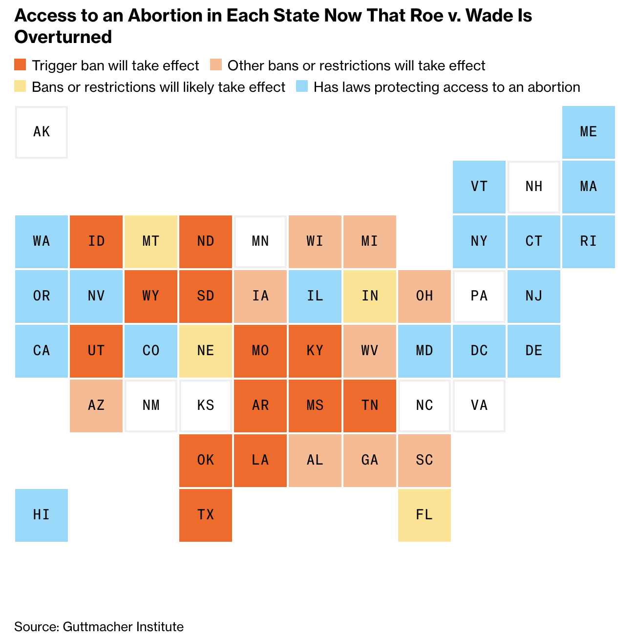 Credit: Bloomberg News/Kelsey Butler, Mathieu Benhamou, Rachael Dottle, Jeremy C.F. Lin, Dave Merrill, Cedric Sam and Raeedah Wahid Credit: Bloomberg News/Kelsey Butler, Mathieu Benhamou, Rachael Dottle, Jeremy C.F. Lin, Dave Merrill, Cedric Sam and Raeedah Wahid This will cause travel surges to nearby states where abortions are legal. My colleagues on the Bloomberg Graphics team calculated that people will have to travel "an average of 276 miles each way to access the procedure." That's about six times farther than when Roe was in effect. 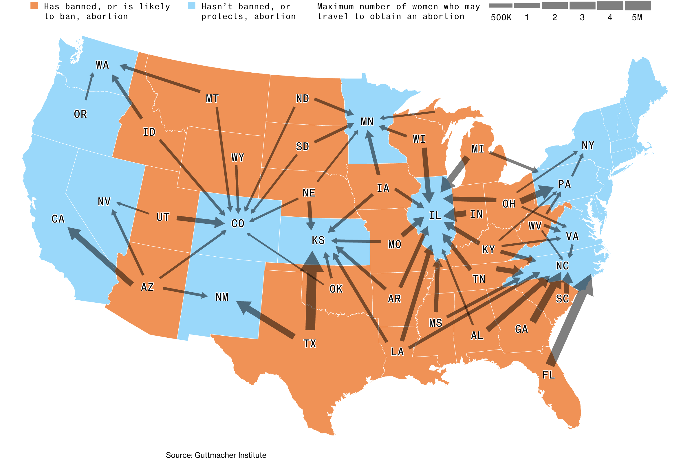 Credit: Mathieu Benhamou, Kelsey Butler and Chloe Whiteaker Credit: Mathieu Benhamou, Kelsey Butler and Chloe Whiteaker Additional maps on the topic: - Family separation among slaves in America was shockingly prevalent (The Economist)
- Maps show how climate change influences today's temperatures across the US (Bloomberg)
- Larry Ellison's Lanai isn't for you — or the people who live there (Bloomberg)
- 3M's forever chemicals crisis has come to Europe (Bloomberg)
- Commute trip by Mode for census tracts, based on where workers live (darrellowensrcd.github.io)
- Map data: false assumptions programers make (solutionspace.blog)
- What extreme heat does to the human body (Washington Post)
- These maps illustrate the seriousness of the western drought (Washington Post)
- A free tool for making noise maps (noisemodelling.readthedocs.io)
- German watchdog launches Google Maps investigation (Reuters)
- These are San Francisco's best parks, according to Google Maps ratings (SF Chronicle)
Thanks for reading. Sign up for MapLab here. — Marie Patino | 


No comments:
Post a Comment